Trail Mountain bike Santa Margalida - Majorque-jour 4 - picafort-pollenca-alcudia-picafort - Photo

Majorque-jour 4 - picafort-pollenca-alcudia-picafort

© OpenStreetMap contributors
Length
Length
52 km
Max alt
Max alt
57 m
Uphill gradient
Uphill gradient
372 m
Km-Effort
Km-Effort  
57 km
Min alt
Min alt
-3 m
Downhill gradient
Downhill gradient
371 m
Boucle
Boucle
Yes
Creation date :
2022-05-31 09:56:24.347
Updated on :
2022-05-31 10:18:58.998

(0 Reviews)

Mountain bike
Mountain bike
3h57
Difficulty : Very difficult

Scan this QR Code to open this trail in the SityTrail application

FREE GPS app for hiking

Logo SityTrail SityTrail

IGN / Geographical institutes

Download SityTrail from the App Store Download SityTrail from Google Play

Logo SityTrail SityTrail World

The world is yours!

Download SityTrail from the App Store Download SityTrail from Google Play Download SityTrail on Huawei AppGallery

About

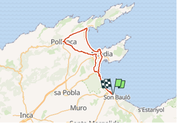
Trail Mountain bike of 52 km to be discovered at Balearic Islands, Unknown, Santa Margalida. This trail is proposed by jeanphi.hennebert.

Elevation profile

Positioning

Country:
Spain
Region :
Balearic Islands
Department/Province :
Unknown
Municipality :
Santa Margalida
Location:
Unknown
Start:(UTM)
513270 ; 4401758 (31S) N.

Trails nearby

Trail Cycle Muro - f-spanje-rondrit-fenetix-san-salvador - Photo
Cycle
gpstracks

Cycle

Very easy
Muro, Balearic Islands, Unknown, Spain
121 km | 140 km-effort
Unknown
No
Trail Cycle Muro - f-spanje-rondrit-cala-vincenz-campanet - Photo
Cycle
gpstracks

Cycle

Very easy
Muro, Balearic Islands, Unknown, Spain
114 km | 131 km-effort
Unknown
No


Close
My subscriptions